ORTHOPHOTOS - FROM PERSPECTIVE TO ORTHOGRAPHIC
PROJECTION
1 Digital Orthophoto
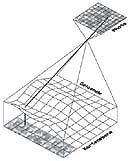
The digital orthophoto is well known from kartographie and arial photogrammetry. A photo as a perspective will be recalculated into an orthographic projection. The shape of the terrain surface is given as a DTM (digital terrain model). This shape is taken into consideration getting the gray value from the perspective for every pixel of the projection into the x-y-plane.If the shape of the terrain can be approximated by a flat surface, projective transformation can be sufficient. This method is applied often in case of architectural facade surveying.
2 Digital Single Image Rectification
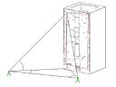
If plane surfaces can be estimated, correction of camera tilt (and direction) can be performed due to the projective relationship between object and image. A polygon of minimum four control points must be known in the object. Comparison between object co-ordinates and measured photo co-ordinates provides the transformation matrix with its eight unknowns. Are there more as four points known, the system can be calculated by over determination. In the latter case accuracy information is provided too.
Instead of control points parallel lines in two directions can be used to constrain the exact geomtry. Two distances in the object are necessary for getting the dimensions.
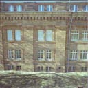
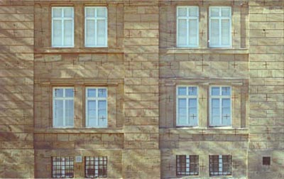
But a digital single image rectification is still a perspective. In architectural applications one can detect this by observing window or door openings. Applying digital image procedures is helpful for improving results. The here presented example is merged from two perspectives, rectified in several planes. Typical windows are rectified separately and mounted into the openings. Using the detectable edges from the rectification planes as a reference.

3 Textured Object Models
Digital image rectifications represent true scale maps. Further processing of the digital image maps result in 3D textured object models. The effort for geometric modeling is reduced. A high degree of detail can be displayed due to the image textures. Early applications are published in:"Pomaska: IMPLEMENTATION OF DIGITAL 3D-MODELS IN BUILDING SURVEYS BASED ON MULTI IMAGE PHOTOGRAMMETRY" (click for PDF document).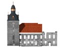
Click into the left image displays the textured object model in perspective view.